My nan Mrs. Daisy knight lived there but not sure for how long. My mum Vera Lucy Knight had George, Gwen, Rose, Janet and me Christine there, then we moved to Roseberry Avenue.
By Chris Howell (06/06/2022)
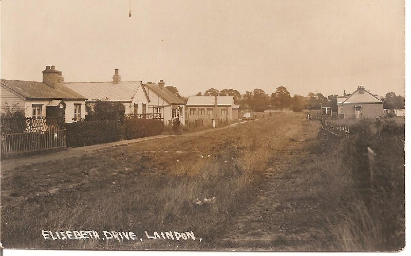
I was living at ‘Rest Haven’ Elizabeth Drive, when the rocket fell on the dairy farm near us. I was the foster child of Mrs. Hurcombe, I was about six years old and I remember the night vividly. A wardrobe fell on my ‘mum’ as I called her, but she was not injured badly. I remember an ‘Aunt Lett’ who lived across the road and there was a family called Hussy who lived opposite.
By Maureen Blain (22/10/2019)
The bungalow opposite Ebenezar Hall was indeed where my Aunt and Uncle Robert and Jess Doodes lived. It was called Ecclesbourne and the Farm destroyed by the rocket was called Fairlight after the glens in Hastings where the Doodes family lived for some time. Ecclesbourne was also damaged and my Aunt’s life was saved by the wardrobe which fell over the bed protecting her.
I spent every summer holiday with my Uncle and Aunt and spent many hours in the company of Jeff Footer and his brothers and sisters playing along the concrete road and shouting at the steam trains travelling over the Wootens Lane Bridge.
It almost broke my Uncle’s heart when they had to move to Belle Hill after the compulsory purchase of the property and a way of life was lost for ever.
By Jean Harvey née Cruttenden (16/08/2012)
I do not know if it will help any historical research into the early photograph of Elizabeth Drive looking east in the days before it was provided with a concrete strip surface, but my archive of 1949 shows that the bungalow occupied by the Baker family was named “Rosebay” and that of the Cooper family was “Winnick”. The bungalow with the well-developed hedge and lychgate on the extreme left of the photo was named “Sunnyside” the home, in 1949, of Lettice Webster, possibly the widow of the Mr Webster unfortunately killed by shrapnel in February 1945 as explained by Jack Doodes. As Mr Doodes has also now confirmed the property opposite in the photograph was “Ecclesbourne”. However, there were two families of the name of Doodes in Elizabeth Drive in 1949. The other property named “Mysotis” was further to the west and thus outside the range of the photo. If I am correct, the Doodes came of a farming family of long-standing in the district, farming at one time at the long-demolished Lee Wootens Farm (not to be confused with “Wootton House” a property that stood in Dry Street). Perhaps Jack could enlighten us further?
The “Ebenezer” Mission Hall stood on the east corner or the un-made-up road Rayleigh Drive. According to my master plan of Basildon New Town that was published superimposed on the map of the district made around the time the photograph was taken, the site of the hall was in present-day Wickhay about fifty yards from its junction with Great Knightleys. One dwelling that was in Rayleigh Drive escaped demolition. It was, I think, named “St Elmo” and survives still in present-day Little Lullaway and is used by The Samaritans as their Basildon base.
It is reasonably certain that the concrete strip road that stretched from Laindon High Road adjacent to Churchill-Johnsons and the Winston Club the full length of Northumberland Avenue and on to Elizabeth Drive was laid in the early nineteen-thirties, probably about 1933 or 1934. It did not run quite the full length of Elizabeth Drive because there was a gap of unmade track for about 100 yards between its end and Lee Wootens Lane a short way beyond the Ebenezer Chapel. This gap was left deliberately, I suspect, to deter vehicles being driven along Lee Wootens Lane and through the narrow bridge hole under the railway to reach Laindon by this route. Lee Wootens Lane was very narrow as can be seen by the still existing pathway running parallel to Nethermayne that once was the Lane’s carriageway on the south side of the railway. I was always puzzled why in wet weather the section of the thoroughfare between the end of the concrete strip portion of Elizabeth Drive and Lee Wootens Lane was so exceptionally wet, so much so that there were often large stones, concrete blocks or baulks of timber left conveniently scattered around so that it was possible to pick one’s way dry shod across the resultant morass.
Studying the large scale map of the area, reveals that there was a water course draining the high ground on the south side of the railway, then containing the Primrose Hill Estate, now a part of Lee Chapel South, that ran through a culvert under the railway embankment and emptied into the basin around the end of Elizabeth Drive. There appeared to be no natural drainage away from this area and the water must have slowly pooled all around that area. No wonder some of the roads had names like Hot Water Lane, Pond Lane and Honeypot Lane. Thus it was that the Development Corporation in redeveloping the district was able to create the lakes of Gloucester Park with their outlet to the fishing lake at the Festival Park. The outflow from these artificial creations eventually flow under the A127, to pass under the eastern end of Wash Road where once there was a ford before flowing into the River Crouch just north of White’s Bridge at Crays Hill. The remnant of the ditch that once took the water flowing in the culvert under the railway can still be seen before it disappears under the Laindon Link along the western perimeter of the Car Park off that highway.
Again, Jack Doodes reminds us, the Ebenezer Mission was run by a Mr.Clark. This was Charles Clark who was the Superintendent of the mission. He lived at “Lavender”, Sandringham Road, Laindon next door to his brother Albert whose bungalow was named “Rosemary”. I am not sure how long they had lived in Laindon but these two properties were certainly among the first to be built on the “Station Estate” created out of the fields of Little Gobions farm destroyed by the building of Laindon station. In the grounds of “Lavender” was the workshop of Mansfield Posters, a business that always advertised itself as having been established in 1905! The two Clark brothers had both obtained the plots of land beyond the limits of those on which their homes had been built. These plots, part of the “Station Rise Estate” were on land once part of Blue House Farm. These plots gave the brothers access to Basil Drive and Tyler Avenue whose roads could be motored over. (Sandringham Road was a mass of deep ruts often water-filled) As a result shortly before the war, Charles Clerk erected a garage for his car which he could use to get to the Ebenezer Mission. All through the war, Charles’s son Douglas nursed this car regularly running it, despite the difficulty in obtaining petrol with the result that it was regularly driven past my house after the war. When the Development Corporation eventually took over the Ebenezer Hall and demolished it, the congregation moved to the Ingaway Chapel in Lee Chapel South.
The impression that Jack Doodes’s photo gives is of sparse development in this part of the district. I think he will, however, agree with me that the people who lived in this area all thought of themselves as part of Laindon. I am reminded that the Ward family who lived at “Applegrove” at the end of Lee Wootens Lane lived even further east and their home just by the railway bridge is too far away to be included in the photograph. In 1923 Mrs Ward was annoyed that the Essex Education Committee made a ruling that all children living north of the railway line must transfer to the council’s new school in Laindon High Road. Mrs Ward kept her kids at home for months because the EEC refused them entry to the Langdon Hills school they had been attending. Mrs Ward considered the new school to be too far for them to walk. Threatened with prosecution, the Ward children finished up at the school in London Road, Vange which they reached via Lee Wootens Lane and Bells Hill.
By John Bathurst (26/05/2012)
The Hall on the left is the Ebenezer Gospel Hall run by Mr Clark. The bungalow on the right opposite is “Ecclesbourne” where Robert and Jess Doodes lived. Robert worked at Shell and had a smallholding on the east side of Le-Wootons Lane opposite where Basildon Hospital is. Jess would sell potatoes and veg at home.
The bungalow on the left rearside was where Mr and Mrs Webster lived until on the 19th Feb 1945 a V2 rocket fell on the farm that was off the photo to the right. A piece of shrapnel from in went through the wall of the bungalow through a dressing table and hit Mr Webster in bed, killing him.
The Doodes family farm dairy was destroyed stopping the use of the wide necked bottles with cardboard stoppers came to an end. I will add a copy of a photo of the bottle I have.
Elizabeth Drive was a continuation of Northumberland Avenue and was where Foderswick is now.
By Jack Doodes (25/05/2012)
Hi all, May I suggest that you click on Our Community, then Places of Worship, the Lee Chapel Religious communities and read the story on Ebenezer Hall in Elizabeth drive.
By Ken Porter (25/05/2012)
Have been trying to place “Elizabeth Drive”. Where was it/is it in Laindon?
Thanks
By Colin Ferrier (24/05/2012)
The hall in the picture looking down Elizabeth Drive is Ebenezer Hall. And I’m pretty sure the house this side of it is Kenwood where I was born. The house across the road from the hall is I think the Doodes’ house. The house next to Kenwood was two houses joined together long ways and it lived the Barkers one side on the other the Coopers. I must say it’s an old photo I would like to know what year it was taken. As I remember it being a made road. Thank you.
By Jeff Footer (24/05/2012)
There appears to be a hall directly in the middle of the picture. I assume this was the “Ebenezer Hall”.


Comments about this page
Add your own comment
My nan Mrs. Daisy knight lived there but not sure for how long. My mum Vera Lucy Knight had George, Gwen, Rose, Janet and me Christine there, then we moved to Roseberry Avenue.
I was living at ‘Rest Haven’ Elizabeth Drive, when the rocket fell on the dairy farm near us. I was the foster child of Mrs. Hurcombe, I was about six years old and I remember the night vividly. A wardrobe fell on my ‘mum’ as I called her, but she was not injured badly. I remember an ‘Aunt Lett’ who lived across the road and there was a family called Hussy who lived opposite.
The bungalow opposite Ebenezar Hall was indeed where my Aunt and Uncle Robert and Jess Doodes lived. It was called Ecclesbourne and the Farm destroyed by the rocket was called Fairlight after the glens in Hastings where the Doodes family lived for some time. Ecclesbourne was also damaged and my Aunt’s life was saved by the wardrobe which fell over the bed protecting her.
I spent every summer holiday with my Uncle and Aunt and spent many hours in the company of Jeff Footer and his brothers and sisters playing along the concrete road and shouting at the steam trains travelling over the Wootens Lane Bridge.
It almost broke my Uncle’s heart when they had to move to Belle Hill after the compulsory purchase of the property and a way of life was lost for ever.
I do not know if it will help any historical research into the early photograph of Elizabeth Drive looking east in the days before it was provided with a concrete strip surface, but my archive of 1949 shows that the bungalow occupied by the Baker family was named “Rosebay” and that of the Cooper family was “Winnick”. The bungalow with the well-developed hedge and lychgate on the extreme left of the photo was named “Sunnyside” the home, in 1949, of Lettice Webster, possibly the widow of the Mr Webster unfortunately killed by shrapnel in February 1945 as explained by Jack Doodes. As Mr Doodes has also now confirmed the property opposite in the photograph was “Ecclesbourne”. However, there were two families of the name of Doodes in Elizabeth Drive in 1949. The other property named “Mysotis” was further to the west and thus outside the range of the photo. If I am correct, the Doodes came of a farming family of long-standing in the district, farming at one time at the long-demolished Lee Wootens Farm (not to be confused with “Wootton House” a property that stood in Dry Street). Perhaps Jack could enlighten us further?
The “Ebenezer” Mission Hall stood on the east corner or the un-made-up road Rayleigh Drive. According to my master plan of Basildon New Town that was published superimposed on the map of the district made around the time the photograph was taken, the site of the hall was in present-day Wickhay about fifty yards from its junction with Great Knightleys. One dwelling that was in Rayleigh Drive escaped demolition. It was, I think, named “St Elmo” and survives still in present-day Little Lullaway and is used by The Samaritans as their Basildon base.
It is reasonably certain that the concrete strip road that stretched from Laindon High Road adjacent to Churchill-Johnsons and the Winston Club the full length of Northumberland Avenue and on to Elizabeth Drive was laid in the early nineteen-thirties, probably about 1933 or 1934. It did not run quite the full length of Elizabeth Drive because there was a gap of unmade track for about 100 yards between its end and Lee Wootens Lane a short way beyond the Ebenezer Chapel. This gap was left deliberately, I suspect, to deter vehicles being driven along Lee Wootens Lane and through the narrow bridge hole under the railway to reach Laindon by this route. Lee Wootens Lane was very narrow as can be seen by the still existing pathway running parallel to Nethermayne that once was the Lane’s carriageway on the south side of the railway. I was always puzzled why in wet weather the section of the thoroughfare between the end of the concrete strip portion of Elizabeth Drive and Lee Wootens Lane was so exceptionally wet, so much so that there were often large stones, concrete blocks or baulks of timber left conveniently scattered around so that it was possible to pick one’s way dry shod across the resultant morass.
Studying the large scale map of the area, reveals that there was a water course draining the high ground on the south side of the railway, then containing the Primrose Hill Estate, now a part of Lee Chapel South, that ran through a culvert under the railway embankment and emptied into the basin around the end of Elizabeth Drive. There appeared to be no natural drainage away from this area and the water must have slowly pooled all around that area. No wonder some of the roads had names like Hot Water Lane, Pond Lane and Honeypot Lane. Thus it was that the Development Corporation in redeveloping the district was able to create the lakes of Gloucester Park with their outlet to the fishing lake at the Festival Park. The outflow from these artificial creations eventually flow under the A127, to pass under the eastern end of Wash Road where once there was a ford before flowing into the River Crouch just north of White’s Bridge at Crays Hill. The remnant of the ditch that once took the water flowing in the culvert under the railway can still be seen before it disappears under the Laindon Link along the western perimeter of the Car Park off that highway.
Again, Jack Doodes reminds us, the Ebenezer Mission was run by a Mr.Clark. This was Charles Clark who was the Superintendent of the mission. He lived at “Lavender”, Sandringham Road, Laindon next door to his brother Albert whose bungalow was named “Rosemary”. I am not sure how long they had lived in Laindon but these two properties were certainly among the first to be built on the “Station Estate” created out of the fields of Little Gobions farm destroyed by the building of Laindon station. In the grounds of “Lavender” was the workshop of Mansfield Posters, a business that always advertised itself as having been established in 1905! The two Clark brothers had both obtained the plots of land beyond the limits of those on which their homes had been built. These plots, part of the “Station Rise Estate” were on land once part of Blue House Farm. These plots gave the brothers access to Basil Drive and Tyler Avenue whose roads could be motored over. (Sandringham Road was a mass of deep ruts often water-filled) As a result shortly before the war, Charles Clerk erected a garage for his car which he could use to get to the Ebenezer Mission. All through the war, Charles’s son Douglas nursed this car regularly running it, despite the difficulty in obtaining petrol with the result that it was regularly driven past my house after the war. When the Development Corporation eventually took over the Ebenezer Hall and demolished it, the congregation moved to the Ingaway Chapel in Lee Chapel South.
The impression that Jack Doodes’s photo gives is of sparse development in this part of the district. I think he will, however, agree with me that the people who lived in this area all thought of themselves as part of Laindon. I am reminded that the Ward family who lived at “Applegrove” at the end of Lee Wootens Lane lived even further east and their home just by the railway bridge is too far away to be included in the photograph. In 1923 Mrs Ward was annoyed that the Essex Education Committee made a ruling that all children living north of the railway line must transfer to the council’s new school in Laindon High Road. Mrs Ward kept her kids at home for months because the EEC refused them entry to the Langdon Hills school they had been attending. Mrs Ward considered the new school to be too far for them to walk. Threatened with prosecution, the Ward children finished up at the school in London Road, Vange which they reached via Lee Wootens Lane and Bells Hill.
The Hall on the left is the Ebenezer Gospel Hall run by Mr Clark. The bungalow on the right opposite is “Ecclesbourne” where Robert and Jess Doodes lived. Robert worked at Shell and had a smallholding on the east side of Le-Wootons Lane opposite where Basildon Hospital is. Jess would sell potatoes and veg at home.
The bungalow on the left rearside was where Mr and Mrs Webster lived until on the 19th Feb 1945 a V2 rocket fell on the farm that was off the photo to the right. A piece of shrapnel from in went through the wall of the bungalow through a dressing table and hit Mr Webster in bed, killing him.
The Doodes family farm dairy was destroyed stopping the use of the wide necked bottles with cardboard stoppers came to an end. I will add a copy of a photo of the bottle I have.
Elizabeth Drive was a continuation of Northumberland Avenue and was where Foderswick is now.
Hi all, May I suggest that you click on Our Community, then Places of Worship, the Lee Chapel Religious communities and read the story on Ebenezer Hall in Elizabeth drive.
Have been trying to place “Elizabeth Drive”. Where was it/is it in Laindon?
Thanks
The hall in the picture looking down Elizabeth Drive is Ebenezer Hall. And I’m pretty sure the house this side of it is Kenwood where I was born. The house across the road from the hall is I think the Doodes’ house. The house next to Kenwood was two houses joined together long ways and it lived the Barkers one side on the other the Coopers. I must say it’s an old photo I would like to know what year it was taken. As I remember it being a made road. Thank you.
There appears to be a hall directly in the middle of the picture. I assume this was the “Ebenezer Hall”.
Add a comment about this page